Civil Solutions Joins the Cityworks Partner Network

Civil Solutions, the geospatial services division of ARH Associates, and a leader in providing geospatial services to local, county and state organizations has joined the Cityworks Partner Network as an Implementation Partner.

“It was a natural fit for us”, states Dave Kunz, GISP, VP of Geospatial Services.  “Many of our existing clients that utilize the Esri ArcGIS platform have been asking us about an integrated GIS asset management system and Cityworks is the pioneer of the GIS-centric approach to asset management.  We are proud to become one of the latest Implementation Partners.”

Integrating GIS technologies within organizational workflows increases overall operational efficiencies, provides greater visibility to the overall operation, and provides readily accessible information to staff, managers, and the public.

For more information, visit the Civil Solutions website https://civilsolutions.biz or email gisinfo@arh-us.com


Civil Solutions Assists Sussex County, NJ with Mapping Sight Triangle Easements Using the ArcGIS Platform

The Sussex County, New Jersey, Engineering Division manages one of the County’s most publicly visible and utilized assets on a daily basis, county-owned roads and bridges.  During the course of normal operations, the County obtains parcels or a portion of parcels (easements) for safety or transportation related activities.  There are hundreds of these type of easements which contain valuable information as part of Engineering’s daily workflow.

The County has been maintaining these assets through different methods, making it difficult to identify and utilizes the information.  The County Engineering Division requested the assistance of Civil Solutions to develop a workflow to better manage and access this data in an easy-to-use uniform method.  In addition, the data is available to field crews assisting the crews with inspections and maintenance activities related to the easement.

This workflow established a pattern for managing data and documents pertaining to spatial locations which can be easily extended to other County Departments.

Site triangle easements are deeded easements with metes and bounds descriptions and filed at the County Clerk’s Office.  Civil Solutions deployed an improved workflow for managing these easements by deploying the ArcGIS Parcel Drafter Solution.  This allows Engineering staff to create GIS polygon data depicting the area of easements via the metes and bounds descriptions within the deed of easement.

ArcGIS Parcel Drafter is a web-based solution allows the user to create polygon land record related data by entering metes-and-bounds descriptions.

As part of the workflow improvement, Civil Solutions worked  with the Engineering staff to develop a data schema for the easement feature class.  This schema contains the attribute information required by the County along with keywords required to retrieve any easement documents that may be in the County’s OnBase EDMS system.


About Civil Solutions

Civil Solutions is ARH’s geospatial technology services division.  Civil Solutions offers a technical staff with expertise spanning over fifty (50) years of project-related insights.  Civil Solutions is an Esri Silver Partner and has provided guidance to many organizations seeking GIS related solutions.


Adams, Rehmann & Heggan Associates, Inc. is a multi-disciplined firm dedicated to providing engineering, land surveying, planning, and geospatial technology services to private, municipal and public clients.  ARH’s strength centers around multiple departments focused on their specific core competencies but intertwined to provide synergistic benefit.  These core strengths include civil engineering, planning, landscape architecture, surveying, global positioning systems (GPS), tax mapping, and geographic information systems (GIS) consulting, data conversion, application development, and enterprise implementation services.

The Town of Hammonton, NJ Implements Esri ArcGIS Hub For COVID-19 Response

The Town of Hammonton and Civil Solutions, a division of ARH Associates, developed an informative website in an effort to provide guidance and information pertaining to COVID-19.  This is in response for the Town’s need to communicate to its residents and local businesses all information pertaining to COVID-19 including live social media feeds and real time dashboards.  The health and safety of all its residents is a high priority and the use of technology has proven to be the best method for conveying this important information.


Built upon Esri’s ArcGIS Hub platform, Civil Solutions developed the website A a single portal for all information regarding the Town’s CORVID-19 response.  The site provides information pertaining to COVID-19 testing, small business financial assistance, food donation programs, migrant farm work guidance and other vital information in multiple languages.


Hammonton COVID-19 ArcGIS Hub Site
https://coronavirus-response-civilsolutions.hub.arcgis.com/


About Civil Solutions

Civil Solutions is ARH’s geospatial technology services division.  Civil Solutions offers a technical staff with expertise spanning over fifty (50) years of project-related insights.  Civil Solutions is an Esri Silver Partner and has provided guidance to many organizations seeking GIS related solutions.


Adams, Rehmann & Heggan Associates, Inc. is a multi-disciplined firm dedicated to providing engineering, land surveying, planning, and geospatial technology services to private, municipal and public clients.  ARH’s strength centers around multiple departments focused on their specific core competencies but intertwined to provide synergistic benefit.  These core strengths include civil engineering, planning, landscape architecture, surveying, global positioning systems (GPS), tax mapping, and geographic information systems (GIS) consulting, data conversion, application development, and enterprise implementation services.

Civil Solutions Assists Passaic County, NJ with Open for Business Status Application

Civil Solutions, a division of ARH Associates develops the Passaic County, NJ Open for Business Status Application.  This application allows businesses within the County to promote their business offerings,  and adjusted operations as the County recovers from COVID-19.  The application provides business owners an opportunity to input their information through brief questionnaire.  For citizens there is an easy to use map which allows a user to find business by viewing the map or by applying filters by business type and/or specific customer services.  The application even identifies where to access PPE supplies and installation services.

Built on the Esri ArcGIS Platform, the business reopening questionnaire is developed using Esri Survey123 for ArcGIS and the business status map is developed using Esri Web AppBuilder for ArcGIS.


About Civil Solutions

Civil Solutions is the geospatial technologies division of Adams, Rehmann and Heggan Associates, Inc. (ARH).  We have become a leader in the geospatial industry through dedicated and focus efforts to secure qualified personnel, gain a variety of project experiences, and reinvest in our resources.  We take great pride in the position that we hold today and understand that it can be gone tomorrow if we do not continue to provide quality services at reasonable pricing, executed with professionalism and personal care.  For more information about Civil Solutions services email gisinfo@arh-us.com or visit www.civilsolutions.biz


For Application URL, Click HERE


Civil Solutions Implements Esri’s ArcGIS Hub to Connect Locally-Owned Restaurants to Front Line Medical Personnel

New Jersey Civil Engineering and GIS Firm Launches Website to Support Locally-Owned Restaurants While Showing State’s ‘Collective Gratitude’ to Front Line Medical Personnel


Media Contact:
Name: George Scott
Title: Executive Vice President
Phone: 609-335-3240
Email address: gscot@arh-us.com

Program Contact:
Name Shannon Warner
Title Director of Client Partnerships
Phone: 609-949-1755
Email address: swarn@arh-us.com


ARH Associates Announces “Send Local Dining to the Heroes Front Lining” through
ARHInTheCommunity.com


(Hammonton, NJ) Richard Rehmann, President of ARH Associates, announced today the official launch of ARHInTheCommunity.com, to support “Send Local Dining to the Heroes Front Lining.” The initiative will collect donations to purchase food directly from locally-owned restaurants and eateries and deliver it at no charge to hospitals, medical complexes, and first responders on the front lines of the COVID-19 pandemic.

Send Local Dining to the Heroes Front Lining” allows ARH and Civil Solutions to use our collective expertise and experience to try and make a positive difference, however minor, during these turbulent times,” said Rehmann.

“We have been working with a number of our public sector clients through these past few weeks, and it is heartbreaking to see communities distressed and small businesses struggling as a result of this public health crisis. At the same time, we have been awed by the bravery and commitment of our medical community. The stories of shifts lasting days instead of hours, working without the proper equipment, and overcoming a surge in patients needing acute care have touched us beyond belief.”

According to the Rehmann, ARH personnel will oversee the program as well as coordinate the scheduling and execution of the deliveries. The site will officially launch with 15 restaurants across 5 New Jersey counties, a list that Rehmann says he expects to see grow daily.

“While the program was originally inspired by our neighbors in downtown Hammonton, we quickly decided to expand it based on the responses the idea has received from the restaurant community, elected officials and community leaders throughout the State. Our goal is to launch a collective Jersey Style Thank You.”

Send Local Dining to the Heroes Front Lining” will run through ARHInTheCommunity.com, a site which was designed and implemented by Civil Solutions, the GIS Division of ARH. The site highlights participating locally-owned restaurants using Esri ArcGIS Hub (a component of the Esri Geospatial Cloud) and links donations to these businesses through a centralized GoFundMe page managed by ARH. ARH staff will lead the effort in coordinating the promotion of the site, food ordering, and the delivery to the hospitals, medical centers and first responders. The program is being managed by ARH In the Community, an internal department focused on community enhancement efforts. 100% of the donations will go directly to the participating businesses.

“While we cannot cover a shift or produce needed equipment, we want to do more. I think like many Americans, we would love the opportunity to buy one of these medical heroes a meal. Now, imagine if we do it collectively, as a community, we can really send a message of appreciation for what they are doing.”

According to Rehmann, the program was designed with the goal of allowing community-based integration into the efforts and anticipates a statewide team effort to make it a success.

“ARH and Civil Solutions work with over 150 communities each year which has made this very personal for us. We are a small business, and we understand dealing with the pressure and the anxiety of the unknown. We feel a special connection to these businesses that are a vital part of the community fabric – they are our neighbors, our friends, and they are integral parts of our lives. It might not be much, but we want to do something to stand in solidarity with them.”

The program was also designed to allow donors to either support a particular restaurant or to support the overall initiative.

“Our employees were an important voice in deciding the best way to serve as community partners in this program. We wanted to build something that will allow any individual to send $10 to buy a meal for medical professionals or to support the locally owned businesses in their community with larger amounts. This accomplishes our goal of building a collective demonstration of appreciation while supporting the locally owned restaurants.

ARH Associates, Civil Solutions and ARH In the Community


ARH is an award-winning civil and design engineering firm headquartered in Hammonton, NJ. With offices in Bloomfield (Essex) and Tinton Falls (Monmouth), the third-generation family-owned firm has over 80 employees consisting of professional engineers, land surveyors, planners, environmental scientists, and permitting experts.

Civil Solutions is the GIS division of ARH specializing in leveraging the functionality, resources, and versatility of geospatial technologies to help our client partners, both the private and public sectors, achieve their vision.

ARH in The Community is the formalization of ARH Associates’ longtime commitment to serving as a community partner. The firm regularly engages in and supports events, organizations, and leaders in their effort to improve the lives of the residents we serve.


Eagleswood Twp, Ocean County, NJ Selects Civil Solutions for New Digital Tax Map

Eagleswood Township in Ocean County, NJ goes digital with its new municipal tax map by selecting Civil Solutions, a division of ARH Associates. Read how the Township is taking advantage of this opportunity to think outside of the box to implement GIS technology.

https://thesandpaper.villagesoup.com/p/eagleswood-takes-proactive-step-by-going-digital-with-tax-map/1801184

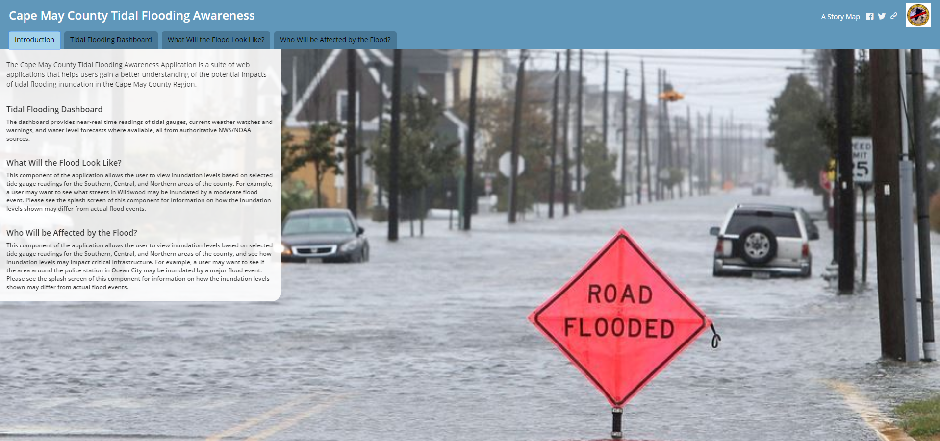
Civil Solutions Implements Esri’s ArcGIS for Water Resources Flooding Storymap for Cape May County, NJ

Civil Solutions, a Division of ARH Associates, implements Esri’s ArcGIS for Water Resources Flooding Storymap in Cape May County, NJ.

Per a recent study by the Union of Concerned Scientists, in New Jersey over 25,000 homes worth nearly 10 billion dollars are at risk of chronic flooding by 2035 due to rising sea levels. With coastal communities like Wildwood and Ocean City that regularly experience flooding issues, Cape May County is one of the most at risk areas. The County of Cape May was looking for a way to better manage their flood risks, responses, and communications, while utilizing a solution that was not prohibitively expensive. Civil Solutions worked with the Cape May Department of Planning and the Department of Emergency Management to develop a tidal flooding management solution that is cost effective, informative, and easy to use and maintain.

The template consists of a tabbed Map Series Story Map that is driven by several web maps. The tabs are meant to answer different questions about the flooding, such as “What Will the Flood Look Like?” and “Who Will be Affected?”. Civil Solutions reviewed sample application components with County planning, engineering, and emergency management staff to determine how to best configure the application to meet the County’s needs while working with the County’s budget.

Civil Solutions approached the development and deployment of the flood management solution as a collaborative effort with County staff, in order to deliver the most effective and efficient solution. Using available data and web services greatly reduces the data management efforts needed to maintain the application. Using ESRI’s cloud hosting in AGO for the applications eliminates the need for management and maintenance of an on premise application deployment. The structure of the application makes it easy to add additional critical point or infrastructure GIS data if needed. The Cape May County Tidal Flooding Awareness web mapping application is a flexible, cost effective flood management solution for the county that requires minimal maintenance and can easily be augmented in the future.

LINKS:

Click Here to View the Application.

Cape May County, NJ Emergency Management Press Release

For more information contact gisinfo@arh-us.com